
Smart Sketchmaps (SmartSkeMa) data collection tools with interactive digital output
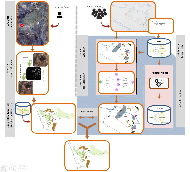
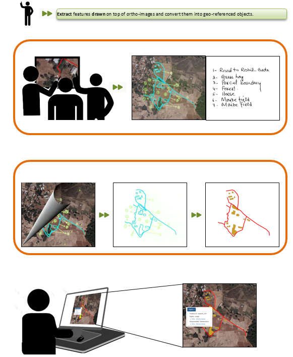
Smart Sketchmaps (SmartSkeMa) is a set of linked sub-tools which can be applied to two workflows, one workflow covers the alignment of sketched information to base map data, while the other workflow concerns the alignment of sketched information to existing ortho-imagery. The workflows outline and sequence the activities which a data collector needs to follow in order to best use the sub-tools provided.
For example, before using the SmartSkeMa system to extract objects represented by symbols from any map, the user must first train the system to recognize these symbols. Therefore, there is a procedure that describes how to train the system to recognize symbols. The set of SmartSkeMa sub-tools consists of:
- a specialized domain model and an associated visual language for sketching;
- a system for automated recognition and extraction of objects in sketch maps;
- a system which integrates sketched information into existing geo-referenced datasets using qualitative representations;
- two supporting tools:
- one for training the symbol detection algorithm for objects that a group of users would want the system to recognise; and
- another for visualizing and interacting with the sketch map information in the context of the existing data.
SmartSkeMa sub-tools target NGOs, private organizations, research institutions, and government agencies using sketching as part of their work in the land/natural resources sectors. The its4land project partner at the University of Muenster (WWU), implemented the sketch based geospatial data recording tool, SmartSkeMa, to capture land tenure data from a local perspective. The implementation of the tool consisted of (i) developing a domain model of concepts used in the description of land resources and tenures within localized contexts (e.g. at community level or within cultural groups); (ii) developing spatial models for representing sketch maps as records of land tenure information; and (iii) developing methods for recognition of land tenure sketch maps and for embedding the sketch maps within existing spatial data sets. The implementation was tested on data collected in the field in Ethiopia and Kenya.
Workflow for aligning sketched information to base map data
Workflow for aligning sketched information to ortho-imagery
To the end user all these sub-tools will be handled as a single integrated software. SmartSkeMa is, therefore, marketed either as a software tool for data collection or a tool for rapid drafting using sketch maps. Usage of the tool may require initial setup and continuous support which are offered as a service.
Video recordings of SmartSkeMa in action can be viewed at www.smartskema.eu.
Recent Comments