
What methods are we using?
Conceptual Underpinnings
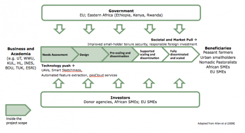
The project is driven by two major conceptual theories: 1) fit-for-purpose land administration; and 2) innovation theory. Fit-for-purpose land administration is part of broader development theories that argue that societal prosperity require secure land tenures, provided by a complete and up-to-date land administration system. Land administration systems are the actors, processes, and technologies that record and maintain information about people, land, and rights (see Dale and McLaughlin, 1999). Information about people and land is usually recorded textually, whilst, land information takes the form of parcel sketch plan and/or maps (digital or otherwise). Despite the simplicity of the idea, only 30-50 countries maintain land administration systems: institution and technical issues are the major reason for deficiencies in other countries. In response, fit-for-purpose land administration suggests technologies should be adapted, selected, and applied to match the capacity and cost constraints of a specific context. Meanwhile, innovation theory posits that inventions can be implemented at scale by integrating the processes and competencies of business, academia, government, investors, and beneficiaries (Allen et al, 2008): technology-push aligns with market-pull via undertaking needs assessment, design, pre- scaling and dissemination, supported scaling, and finally full dissemination. The proposal is premised on both theoretical underpinnings.
Disciplinary Diversity
Within the innovation process, inspired by fit-for-purpose land administration, other sub-theories from engineering, geo-informatics, public administration, and economics are utilized. These include theories enabling spatial technology design: ontological analysis, theory, photogrammetric theory, remote sensing, computer vision, semi-supervised classification, UAV technology and legislation, human-computer interaction, and information system design. In addition, theories for understanding and designing governance systems, capacity development and business models are also utilized: network theory (Latour, 2005), graph theory (Tutte, 2001), complex adaptive system theory (Grus et al., 2010), the agent based modelling (ABM) approach (Bonabeau, 2002; Ligtenberg et al., 2009), knowledge representation and reasoning, geodetic organizational development, open systems theory, and knowledge transfer and use. These sub-theories provide conceptual grounding for undertaking the different phases and work packages involved in the innovation process. Because there is interaction between the different phases (i.e. needs assessment, design, and scaling) the project is necessarily transdisciplinary: as illustrated in the work package descriptions, particularly work package 2 (WP2), reconciliation and leveraging of the different theoretical underpinnings supports the flow of the work.
Technological Readiness
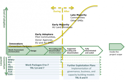
Regarding Technology Readiness Levels (TRL) the project mainly spans TRL 5 to 7. The core technologies of interest to the project require validation, demonstration, and prototyping in a new application area: the basic principles (TRL 1), technology concept (TRL 2), and lab proof-of-concept and validation (TRL 3 and 4) are largely completed for UAVs, smart sketchmaps, automated feature extraction, and geocloud services (although some research work is required in the project). Consequently, the project activities focus on integration, validation (TRL 5), demonstration (TRL 6), and prototyping (TRL 7), in the context of land administration workflows in Ethiopia, Kenya, and Rwanda. Complete system qualification (TRL 8) and complete operationalization of an actual system (TRL 9) lie outside the scope of the project – however, work packages 6 and 7, along with the dissemination and exploitation plan – ensure these readiness levels are nurtured in the final phases of the project, enabling subsequent exploitation.
Gender Sensitivity
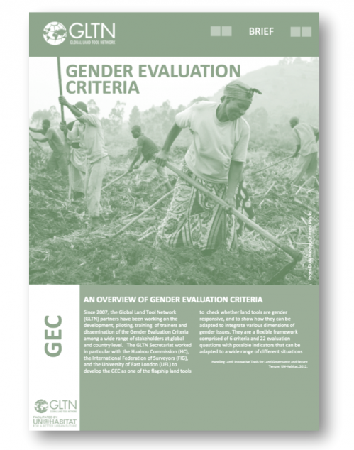
Gender sensitive analysis and design form are recognized at national and international levels as a key challenge for land tenure governance, including recording: globally, women only constitute roughly 5% of registered land owners. The bias against females in both conventional and customary land tenure and administration systems is recognized within UN-Habitat, GLTN, FAO, and the World Bank: guidelines, tools and methods are now available for ensuring gender sensitive approaches relating to land administration. its4land will utilize these approaches. Specifically, the GLTN’s toolkit ‘Gender Evaluation Criteria’ (http://www.gltn.net/index.php/resources/publications/publications-list/finish/3-gltn-documents/31-gender- evaluation-criteria-for-large-scale-land-tools-brief-eng-2012) will be utilized for developing the data acquisition and analysis tools as part of the needs assessment work package (WP2) and governance model package (WP7). In addition, use will be made of the EU’s Gendered Innovation tools in the same phases – specifically, those relating to question formulation and gender aware innovation processes more generally (http://ec.europa.eu/research/science-society/gendered-innovations/index_en.cfm). To support these efforts, it is intended that the Hauriou Commission, the internationally recognized women’s advocacy group, joins the project Advisory Board.
Recent Comments