
![]()
What: its4land scientific publications about the match between the use of Unmanned Aerial Systems and the needs of communities and governments in the land sector in Rwanda.
Where: MDPI – Remote Sensing journal
When: 1 May 2019
What: “Unmanned Aerial System Imagery, Land Data and User Needs: A Socio-Technical Assessment in Rwanda“ – https://www.mdpi.com/2072-4292/11/9/1035
by: Stöcker, C.; Ho, S.; Nkerabigwi, P.; Schmidt, C.; Koeva, M.; Bennett, R.; Zevenbergen, J.
Abstract: Unmanned Aerial Systems (UAS) are emerging as a tool for alternative land tenure data acquisition. Even though UAS appear to represent a promising technology, it remains unclear to what extent they match the needs of communities and governments in the land sector. This paper responds to this question by undertaking a socio-technical study in Rwanda, aiming to determine the match between stakeholders’ needs and the characteristics of the UAS data acquisition workflow and its final products as valuable spatial data for land administration and spatial planning. A needs assessment enabled the expression of a range of land information needs across multiple levels and stakeholder sectors. Next to the social study, three different UAS were flown to test not only the quality of data but the possibilities of the use of this technology within the current institutional environment. A priority list of needs for cadastral and non-cadastral information as well as insights into operational challenges and data quality measures of UAS-based data products are presented. It can be concluded that UAS can have a significant contribution to match most of the prioritized needs in Rwanda. However, the results also reveal that structural and capacity conditions currently undermine this potential.
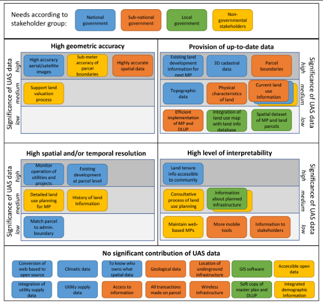
Figure 1: Graphical abstract


Recent Comments