Recent Tweets

Recent Comments

/News/

New its4land ISI publication about UAS

What: its4land scientific publications about the match between the use of Unmanned Aerial Systems and the needs of communities and governments in the land sector in Rwanda. Where: MDPI – Remote Sensing journal When: 1 May 2019 What: “Unmanned Aerial System Imagery, Land Data and User Needs: A Socio-Technical Assessment in Rwanda“ - https://www.mdpi.com/2072-4292/11/9/1035 by: [...]


By | May 15th, 2019|News|0 Comments

ISPRS Geospatial Week 2019

What: its4land toolbox launch event at ISPRS Geospatial Week 2019 Where:  Enschede, Netherlands When: 10-14 June 2019 Who: Mila Koeva, its4land coordinator, is one of the organizers During the ISPRS Geospatial Week 2019, its4land will organize a launch event for the its4land toolbox. This will take place on Wednesday 12 June 2019. its4land programme 11 00 – 12 30 [...]

By | May 10th, 2019|Events, Previous Events|0 Comments

4th Annual Land Conference of the Institute of Land Administration at the Bahir Dar University

What:  4th Annual Land Conference of the Institute of Land Administration at the Bahir Dar University Where:  Bahir Dar University, Ethiopia When: 24-25 May 2019 Who: Tarek Zein (Hansa Luftbild, Germany) Why: Tarek will present the its4land land administration toolbox

By | May 5th, 2019|Events, Previous Events|0 Comments

Geospatial World Forum 2019

What: Geospatial World Forum Where:  Amsterdam, Netherlands When: 02-04 April 2019 Who: its4land is planning to give a masterclass/workshop

By | May 3rd, 2019|Events, Previous Events|0 Comments

World Bank conference 2020

What: Land and Poverty Conference 2020: Institutions for Equity and Resilience Where:  Washington DC, United States When: 16-20 March 2020

By | May 1st, 2019|Events, Upcoming Events|0 Comments

Concept of Extended LADM Ontology

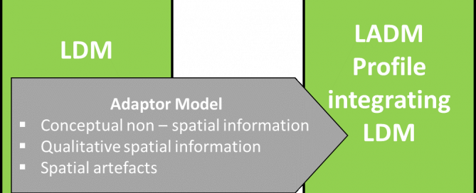
The SmartSkeMa team at IfGI (University of Muenster) successfully submitted their sixth project deliverable, D3.6, titled Concept of extended LADM ontology. The deliverable report outlines how its4land’s SmartSkeMa system addresses the mismatch between informal, indigenous, or customary land tenure systems documented using custom Local Domain Models (LDM) and the Land Administration Domain Model (LADM). The [...]

By | April 29th, 2019|News|0 Comments

Geospatial World Forum

What: Geospatial World Forum 2019 Geospatial World Forum is a collaborative and interactive platform, which demonstrates collective and shared vision of the global geospatial community. It is an annual gathering of geospatial professionals and leaders representing the entire geospatial ecosystem Where: Teats art and event park, Amsterdam, Netherlands When: 3 April 2019 Who: Sophie Crommelinck, [...]

By | April 4th, 2019|News|0 Comments

World Bank conference 2019

What: Land and Poverty Conference 2019: Catalyzing Innovation Where:  Washington DC, United States When: 25-29 March 2019 Who: its4land gave a 90-minutes masterclass  on Friday 29 March as well as three presentations. Output: Find below the programme of the its4land masterclass that we conducted, the presentations that were given and the videos that were shown. The programme of the [...]

By | April 1st, 2019|News|0 Comments

Meeting – its4land MT26

What: its4land MT26 Where: Online (participants from Netherlands, Belgium, Germany, Rwanda, Kenya and Ethiopia) When: Thursday 14 March 2019 (14:00 – 16:00 CET) Who: its4land MT members Why: The MT meets on a regular basis, particularly with regards to milestone accountability and deliverables.

By | April 1st, 2019|Meetings|0 Comments

its4land roadmap meeting – 6

What: sixthits4land roadmap meeting Where: ITC, Enschede, Netherlands/online (Skype) When: Wednesday 6 March 2019 Who: all project partners Why: The main goal of these meetings is to assess whether we are on track with the initially planned tasks for the project, whether we are deviating and if so what measures should be taken.

By | March 29th, 2019|Meetings|0 Comments