
What: software architecture to disseminate its4land tools ready
When: 31 July 2018
Who: Hansa Luftbild, Germany
The “Publish and Share” work package (work package 6), led by Hansa Luftbild, has developed together with the other technical work packages in its4land and based on the results from the requirements analysis conducted earlier in the project, a software architecture to disseminate the tools and data created by its4land.
The “Publish and Share” platform can be considered on the one hand as a runtime environment for the tools developed in its4land and on the other as provider of data and information for existing Land Administration Systems (LAS) or other tools. The developed architecture allows a mobile usage of the its4land tools, as well as online usage following a geocloud approach.
The core elements of the Publish and Share architecture are:
- A set of public REST-APIs to interact with the Publish and Share platform
- A Docker based runtime environment for tools developed in Its4land
- A set of data stores for alphanumeric, geo, binary and image data
- OGC services for data dissemination
External systems like LAS or planning systems can use this to integrate data into their own process, based on the specific national rules. The modelling of interfaces to external systems follows the concepts introduced by Land Administration Domain Model (LADM).
Two deliverables (D6.1 and D6.2) describe the “Publish and Share” platform from different perspectives. D6.1 focusses on the aspects of image processes in order to handle the output from the“Fly and create” work package (UAV imagery) and the “Automate it” work package (Automated feature extraction). D6.2 considers the “Publish and Share” Platform from the point of view of a qualitative data processing platform as required in the “Draw and Make” work package that produces smart sketch maps.
Available for download:
- deliverable 6.1: “Mobile Image Processing Platform”.
- deliverable 6.2: “Mobile Qualitative Data Processing Platform“
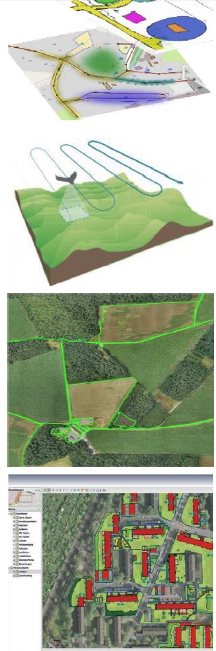
From top to bottom: ‘Draw and Make’ work package produces smart sketch map, ‘Fly and Create’ produces UAV imagery, ‘Automate it’ produces automatically extracted boundaries and these come all together in the fourth image through the ‘Publish and Share’ platform


Recent Comments