
Latest Tech News
FOSS4G 2019
What: its4land presentation at FOSS4G conference 2019 Where: Bucharest, Romania When: 26-30 August 2019 Who: Ivan Ivanov (University of Twente/ITC, Netherlands) The annual worldwide FOSS4G conference took place in Bucharest, where the its4land project was presented. A key focus on the presentation was the QGIS plugin, as a convenient tool for filtering out useful line features among false [...]
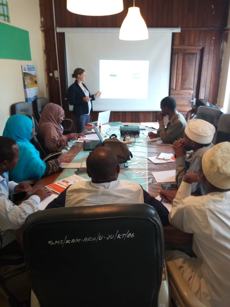
Data collection in Zanzibar
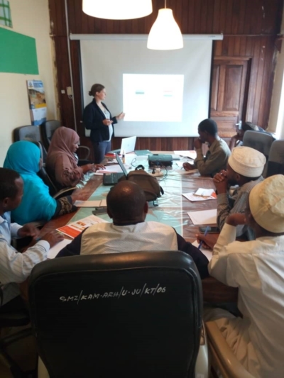
What: Data collection in Zanzibar Where: Stone Town, Commission of Lands Zanzibar When: 19 July 2019 Who: Claudia Stöcker, University of Twente/ITC, Netherlands Why: Work package 4, which is about UAV-based data acquisition for land administration, is now getting towards the end of the project and seeks for validation and further use cases of the [...]

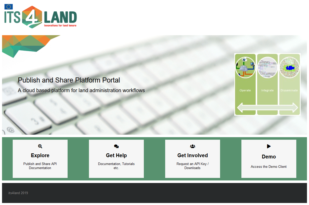
its4land Publish and Share platform ready for testing
The Hansa Luftbild team has now released the Publish and Share platform for internal and external tests and evaluations. We have developed the main technical components of Publish and Share to Technology Readiness Level (TRL) 5-6. The platform has been deployed on the AWS cloud platform, for further testing and optimization in order to reach [...]

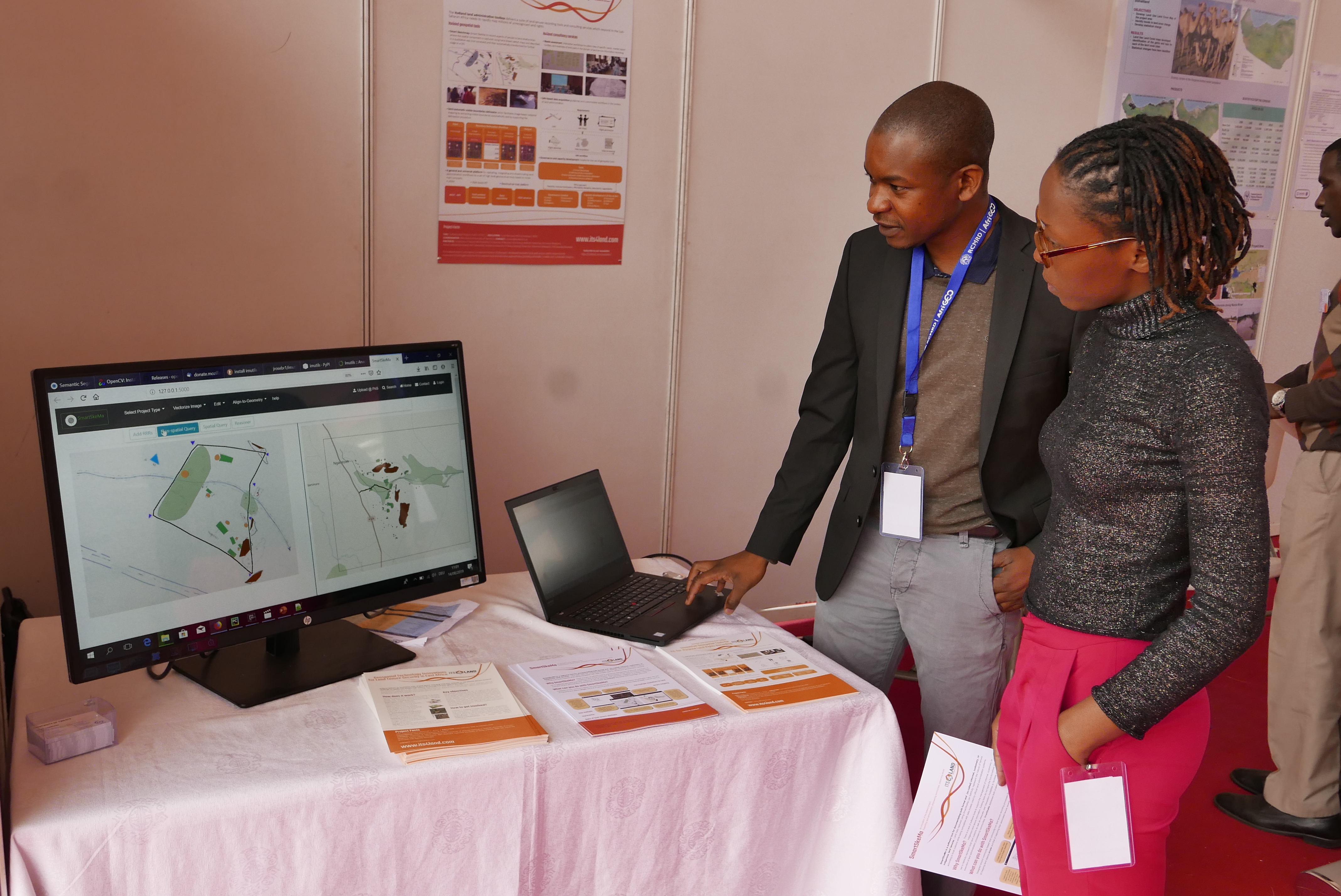
its4land at RCMRD International Conference & 4th AfriGEO Symposium
What: its4land presentations and exhibition at RCMRD International Conference & 4th AfriGEOSS Symposium Where: Nairobi, Kenya When: 13-14 August 2019 Who: Sophie Crommelinck, (University of Twente/ITC, Netherlands), Malumbo Chipofya (University of Muenster, Germany), Tarek Zein (Hansa Luftbild, Germany), Kaspar Kundert (ESRI, Rwanda) During the RCMRD International Conference & 4th AfriGEOSS Symposium, its4land presented the outcomes of the project. The [...]
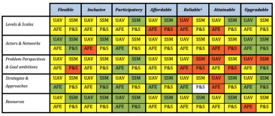
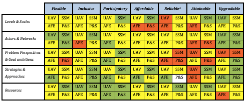
Assessing compatibility of a country’s Governance and Capacity with the its4land land administration toolbox using the newly developed its4land scorecard
its4land’s work package 7 (WP7) – ‘Govern and Grow: Sustainable governance and capacity building’ recently delivered its 4th deliverable (D7.4). WP7 deals specifically with the development of a governance and capacity development model to support the implementation and evaluation of innovative technologies and their use to meet stakeholders' needs so that the innovation process can [...]
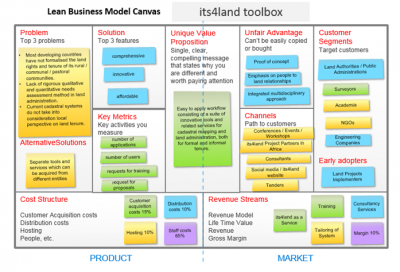
Business model for its4land tools ready
Work Package 8 (WP8) titled Capitalize has reached a major achievement with the project deliverable 8.1 being submitted and released. This deliverable covers the design of the appropriate business model and the definition of the business plan, which aims at developing a sustainable business model for the dissemination and commercialization of the land tenure recording [...]
its4land toolbox launch event at ISPRS Geospatial Week 2019
What: ISPRS Geospatial Week 2019 Where: Enschede, The Netherlands When: 10-14 June 2019 Who: Malumbo Chipofya, Sahib Jan, Angela Schwering (University of Münster, Germany), Tarek Zein, Christian Timm (Hansa Luftbild, Germany), Kaspar Kundert (ESRI, Rwanda), Joep Crompvoets (KU Leuven, Belgium), Mila Koeva, Claudia Stöcker, Sophie Crommelinck and Chiel Stroeven (ITC, Netherlands) Why: On 10 to 14 June [...]
4th Annual Land Conference Bahir Dar Ethiopia
What: 4th Annual Land Conference of the Institute of Land Administration at the Bahir Dar University Where: Bahir Dar University, Ethiopia When: 24-25 May 2019 Who: Tarek Zein (Hansa Luftbild, Germany) Output: On 24 and 25 May the 4th Land Conference of the Institute of Land Administration at the Bahir Dar University took place. The its4land project consortium [...]
New its4land ISI publication about UAS
What: its4land scientific publications about the match between the use of Unmanned Aerial Systems and the needs of communities and governments in the land sector in Rwanda. Where: MDPI – Remote Sensing journal When: 1 May 2019 What: “Unmanned Aerial System Imagery, Land Data and User Needs: A Socio-Technical Assessment in Rwanda“ - https://www.mdpi.com/2072-4292/11/9/1035 by: [...]
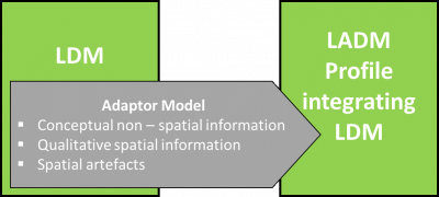
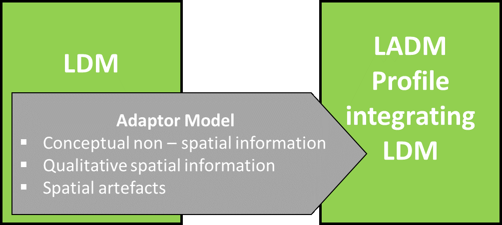
Concept of Extended LADM Ontology
The SmartSkeMa team at IfGI (University of Muenster) successfully submitted their sixth project deliverable, D3.6, titled Concept of extended LADM ontology. The deliverable report outlines how its4land’s SmartSkeMa system addresses the mismatch between informal, indigenous, or customary land tenure systems documented using custom Local Domain Models (LDM) and the Land Administration Domain Model (LADM). The [...]
Recent Comments